


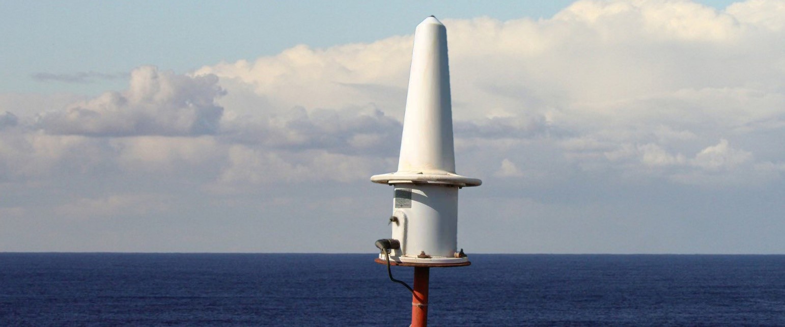
Racon
RACON (Radar beacon) is used by ports and harbor authorities to help mariners easily identify the location of fixed or floating Aids to Navigation. The IMO also refers to RACON as radar transponders that operate by receiving/transmitting data using Morse code, when a radar signal is identified. The signal is transmitted at the same frequency as that of the triggering radar, enabling the coded navigational signal to automatically appear on a ships radar. RACON transmission is extremely accurate and of great assistance to mariners on approach. RACON is normally used in high-risk areas to highlight critical assets such as:
- Lighthouses
- Landfall and obstructed coastlines
- Offshore platforms and structures
- New or unchartered hazards
- Centre and turning points to navigate large vessels
The primary benefit of using RACON as a connectivity option is its availability. The device will transmit in almost any type of weather, unaffected by fog or poor weather and sea conditions. The RACON signal appears alongside other radar signals on the bridge of the ship, helping the mariner to make navigational decisions. Mariners love a RACON because of its range, reliability, availability, and visibility.
RACON’s are a highly responsive, single piece device that transmits to the more common X-band (10GHz) and/or S-band (3GHz) frequencies for more specialized applications. The RACON range is line-of-sight, typically greater than 15NM. This is substantially longer than your typical Aid to Navigation. For an optimum operating range, ensure there is a clear line of view, as any obstruction can hinder the performance of the RACON signal.
TECHNICAL PARAMETERS
Antenna – size dependent on the transmission band
Receiver – frequency, blocking period, primary radar pulse length
Transmitter – frequency
Response – Delay after receipt, identification coding (Morse letter), duration
A RACON is normally battery powered (12V) and recharged by solar panels. They are easy to program onsite via connection to the RS232 communication port using a laptop computer. Once installed and commissioned, little ongoing maintenance of the RACON is required.
Govt. of India
Ministry of Ports, Shipping and Waterways
Directorate General of Lighthouses and Lightships
RACON DETAILS
| SL NO | NAME OF STATION | CODE | DIRECTORATE |
|---|---|---|---|
| 1 | Jakhau | M | VTS Gandhidham (07) |
| 2 | Mandvi | G | |
| 3 | Navlakhi | B | |
| 4 | Navinal | C | |
| 5 | Pirotan | K | |
| 6 | Bural | D | |
| 7 | Okha | O | |
| 8 | Kachhigadh | K | Jamnagar (09) |
| 9 | Dwarka | G | |
| 10 | Porbandar | D | |
| 11 | Veraval | K | |
| 12 | Diu Head | D | |
| 13 | Savaibet | M | |
| 14 | Gopnath | G | |
| 15 | Alang | C | |
| 16 | Piram | B | |
| 17 | Luhara Pt | D | Mumbai (05) |
| 18 | Hazira | K | |
| 19 | Umargaon | M | |
| 20 | Korlai Fort | O | |
| 21 | Ratnagiri | G | |
| 22 | Aguada | O | Goa (04) |
| 23 | Vengrula Rocks | D | |
| 24 | Surathkal | C | |
| 25 | Oyster Rock | D | |
| 26 | Mount Dilli | K | Cochin (11) |
| 27 | Beypore | G | |
| 28 | Androth | D | |
| 29 | Kiltan (South) | O | |
| 30 | Agatti | B | |
| 31 | Kadmath | G | |
| 32 | Villinjam | O | |
| 33 | Minicoy | G | |
| 34 | Suhelipar | O | |
| 35 | Kavaratti | K | |
| 36 | Vypin | K | |
| 37 | Kanyakumari | C | Chennai (09) |
| 38 | Pandian Tivu | O | |
| 39 | Manapad | G | |
| 40 | Muttom | M | |
| 41 | Porto Novo | B | |
| 42 | Nagapattinam | G | |
| 43 | Pondicherry | D | |
| 44 | Chennai | K | |
| 45 | Pulicat | B | |
| 46 | Krishnapatnam | C | Visakhapatnam (05) |
| 47 | Ramyapatnam | K | |
| 48 | Vakalpudi | G | |
| 49 | Antervedi | B | |
| 50 | Dolphin’s Nose | O | |
| 51 | Paradeep | K | Kolkata (03) |
| 52 | Gopalpur | G | |
| 53 | Dariapur | G | |
| 54 | East Island | D | Port Blair (11) |
| 55 | North Point | K | |
| 56 | Keating Point | O | |
| 57 | Indira Point | G | |
| 58 | Chowra Island | B | |
| 59 | Prongs Reef | G | |
| 60 | BLQ II (Bassein Field) BE 19 °07.39’ N 72°06.44’ E |
C | |
| 61 | Neelam (Heera Field) NLM-11 18 °48.41’ N 72°20.04’ E |
G | |
| 62 | SHQ (South Field) WI – 10 . 19 °17’33.41” N 71°16’54.7” E |
D | |
| 63 | WIN (North Field) WI-219 °37.84’ N 71°17.77’ E | B | |
| 64 | Tapti (STD) 20°32.44’ N 71°58.29’ E |
C |


