


DGNSS
DIFFERENTIAL GLOBAL NAVIGATION SATELLITE SYSTEM (DGNSS)
A Global Navigation Satellite System (GNSS) is a space based positioning, navigation and time distribution system designed for worldwide use. Global Navigation Satellite System (GNSS) refers to a constellation of satellites providing signals from space that transmit positioning and timing data to GNSS receivers to have Global coverage. The receivers then use this data to determine the location. Major GNSS are as follows.
- GPS(USA’s NAVSTAR Global Positioning System)
- GLONASS(Global'naya Navigatsionnaya Sputnikovaya Sistema) of Russia
- Galileo of Europe
- BeiDou Navigation Satellite System of China
- Navigation with Indian Constellation(NAVIC)
Differential GNSS (DGNSS) is a kind of GNSS Augmentation system based on an enhancement to primary GNSS constellation(s) information by the use of a network of ground-based reference stations which enable the broadcasting of differential information to the user to improve the accuracy of his position. Differential GNSS (DGNSS) system is a means of improving the accuracy of GNSS and providing integrity monitoring to the user. DGNSS involves having reference stations, at precisely known locations that provides real-time corrections and integrity information for GNSS signals. DGNSS systems provide shore‐to-ship services.
- The DGNSS allows the users to increase the position accuracy from 100 meters to 5 meters making it more useful and precise to navigation.
- Each DGNSS Broadcast Station provides DGNSS corrections to users in its region via marine radio beacon signals. Marine radio beacons, which operate in the 283.5 to 325.0 KHz frequency band, broadcast DGNSS corrections by modulating the normal beacon direction-finding signal with the DGNSS correction information. The signals are received by the beacon receiver on board the user’s vessel and are demodulated to recover the DGNSS corrections.
INDIAN DGNSS NETWORK
- 23 DGNSS stations under DGLL compute & broadcast DGNSS correction & Beacon Almanac, reference station information, failure detection & health status of DGNSS equipment seamlessly covering the Indian waters including Andaman and Nicobar and Lakshadweep Islands and providing better than 05 meters position accuracy up to 100 Nm from the coast.
- National DGNSS Monitoring station at Bhandup, Maharashtra commissioned in the year 2019.
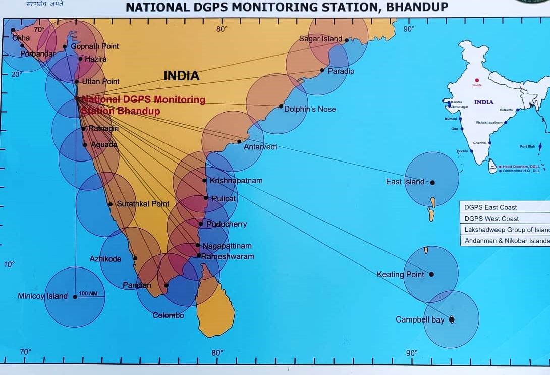
DGPS EAST COAST: 10
DGPS WEST COAST: 09
LASKHYADWEEP GROUP OF ISLANDS: 01
ANDAMAN & NICOBAR ISLANDS:03
DETAILS OF DGNSS STATIONS
| NAME OF STATION | RS1 | RS2 | Frequency(KHz) |
|---|---|---|---|
| OKHA | N 22 28 35.28200 E 069 O4 11.11494 H-44.141mts. ID :- 401 |
N 22 28 35.24182 E 069 O4 11.19083 H -44.141mts. ID :- 402 |
296.0 |
| UTTAN | N 19 16 42.18192 E 72 46 50.85529 H -14.8618m ID :- 406 |
N 19 16 42.19918 E 72 46 50.85366 H -14.8612m ID :- 407 |
306.0 |
| AGUADA | N 15 29 32.17852 E 73 46 20.84846 H -4.706M ID :- 410 |
N 15 29 32.17337 E 73 46 20.84752 H -4.735M ID :- 411/td> |
288.0 |
| SURATHKAL | N 13 00 17.02686 E 74 47 23.38618 H -68.354M ID :- 412 |
N 13 00 17.00844 E 74 47 23.30466 H -68.354M ID :- 413/td> |
320.0 |
| AZHIKODE | N 10 12 13.03787 E 76 09 27.30537 H -88.2402M ID :- 414 |
N 10 12 12.96224 E 76 09 27.33427 H -87.216M ID :- 415 |
320.0 |
| MINICOY | N 8 16 09.95776 E 73 0133.26505 H -80.934M ID :-418 |
N 8 16 09.95605 E 73 0133.35262 H -74.094M ID :-419 |
306.0 |
| PONDICHERRY | N 11 54 59.02836 E 79 49 51.72534 H -84.6393M ID :- 422 |
N 11 54 69.01857 E 79 49 51.84554 H -84.618M ID :- 423 |
312.0 |
| DOLPHIN'S NOSE | N 17 40 41.98458 E 083 17 29.14874 H 93.8403M ID :-428 | N 17 40 41.93560 E 083 17 29.04196 H 93.854M ID :-429 | 295.0 |
| SAGAR ISLAND | N 21 39 30.55691 E 88 02 49.10468 H -54.583M ID 434 |
N 21 39 30.51435 E 88 02 49.04507 H -54.576M ID 435 |
218.0 |
| KEATING POINT | N 09 15 21.14906 E 92 46 31.38245 H -50.814M |
N 09 15 21.29134 E 92 46 31.46443 H -50.759M |
317.0 |
| PORBANDAR | N 21 37 21.219423 E 069 37 12.003770 |
N 21 37 21.291790 E 069 37 11.968630 |
293.0 |
| RATNAGIRI | N 16 59 16.373760 E 73 16 20.599300 |
N 16 59 16.46630 E 73 16 20.485350 |
308.0 |
| NAGAPPATINAM | N 10 45 58.133290 E 79 51 00.372440 |
N 16 59 16.036090 E 73 16 20.376190 |
323.0 |
| KRISHNAPATNAM | N 14 15 17.533210 E 80 07 33.235470 |
N 14 15 17.464800 E 80 07 33.358240 |
297.0 |
| PANDIAN THIVU | N 08 47 08.912560 E 78 11 48.559720 |
N 08 47 08.898860 E 78 11 48.363840 |
309.0 |
| PARADIP | N 20 15 21.040350 E 86 39 19.882780 |
N 20 15 21.963630 E 86 39 19.693780 |
290.0 |
| ABTERVEDI | N 16 19 01.118650 E 81 43 32.844620 |
N 16 19 01.138110 E 81 43 32.700830 |
320.0 |
| GOPNATH PT | N 21 12 11.879410 E 72 06 31.199050 |
N 21 12 11.7515390 E 72 06 31.160800 |
299.0 |
| HAZIRA | N 210 05’ 31.433 E 720 38’ 34.607 |
N 210 05’ 31.433 E 720 38’ 34.607 |
312.0 |
| PULICAT | N 130 25’ 15.943 E 800 19’36.393 |
N 130 25’ 16.052 E 800 19’36.477 |
319.0 |
| EAST ISLAND | N 130 37’ 52.039 E 930 02’ 49.902 |
N 130 37’ 51.965 E 930 02’ 49.832 | 313.0 |
| RAMESHWARAM | N 090 17’01.892 E 790 18’31.828 |
N 090 17’01.892 E 790 18’31.828 |
311.0 |
| CAMPBELL BAY | N 090 17’01.892 E 790 18’31.828 |
N 090 17’01.892 E 790 18’31.828 |
289.0 |
| DGNSS MONITORING STATION BHANDUP |


